
In the early 20th century, British explorer Percy Fawcett made several forays into the Amazon in search of proof of the ancient civilization he believed once existed in the land. In 1925, on another quest to find the 'lost city of Z', the expedition and its members have since disappeared into the jungle ......
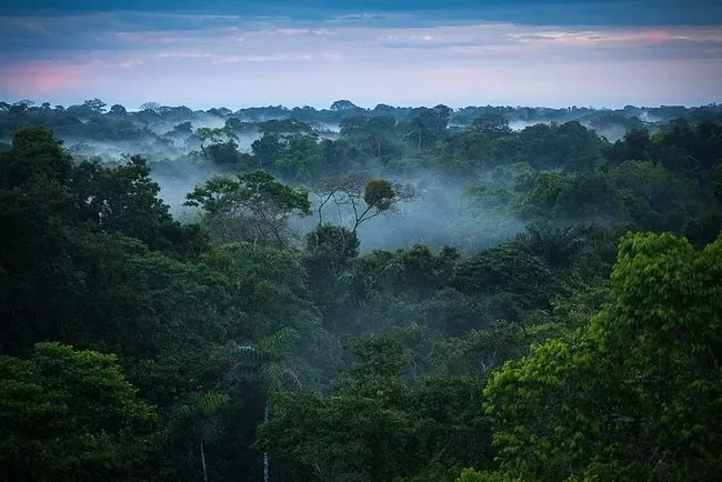
▲Image from: Culture Trip
Percy's adventure led Conan Doyle to write the novel The Lost World based on him as the main character, and he became the inspiration for the movie Indiana Jones. This last adventure was also made into the movie Lost City of Z (a movie that also featured the new Batman (Robert Pattinson) and Spider-Man (Tom Holland), who hadn't turned into a superhero at the time)

▲Lost City of Z stills, image from: Douban
The mysterious lost city in the Amazon jungle has also become an even more intriguing legend. Now, the legend is no longer just a legend, as a new study by a team of scientists published in the journal Nature suggests that ancient cities do exist in the Amazon.
In previous studies, traces of human settlement have been found in the now untouched Amazon jungle, in an area known as the "Casarabe Culture" (Casarabe Culture Zone).
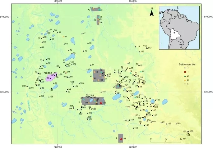
▲Image from: Nature
This cultural area, which existed from about 500 A.D. to 1400 A.D., covers an area of about 4,500 square kilometres. Analysis of previous remote sensing and field surveys indicates that there were canals and causeways, and that people living there would have eaten corn, hunted and fished.
Although it has been established that people once lived there, little is still known about aspects such as the civic ceremonial architecture at the main site and the understanding of the regional organization of the Kasarabe cultural settlement.
▲ Image from: Nature
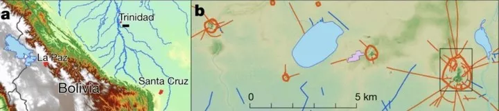
To learn more about the people and civilizations that once existed on the land, scientists used LIDAR (Laser Detection and Ranging System) from high altitude in a helicopter to map six areas where major settlements are known to have been concentrated.
If viewed from the air with the naked eye, the dense jungle canopy would obscure the ground conditions, but LiDAR can cut through these trees and 'render' the past.
▲Image from: Nature
The two large settlements of Cotoca (c. 147 ha) and Landívar (c. 315 ha) are already known, but their exact size and architectural details need to be understood with the help of a LiDAR survey.
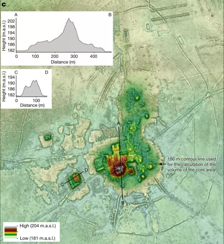
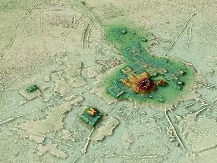
The results of the obtained LiDAR data combined with the results of the preliminary archaeological survey and remote sensing data indicate the presence of a number of ritual structures in these large settlements, including stepped platforms topped by U-shaped structures, rectangular platform mounds and conical pyramidal structures. Artificial terraces and platform structures are present in the core of the Landívar site.
Both large settlements are surrounded by three concentric defensive structures consisting of moats and walls, with an average of 10 sites within a 10 km radius of each settlement, which are spatially distributed in clusters interconnected by causeways and canals.
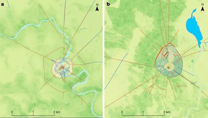
▲Image from: Nature
The central role of Cotoca as a major site is also highlighted by the system of canals and causeways that radiate in all major directions from the base platform. A 7 km long canal brings water to Cotoca from elsewhere, and these are indicative of the scale of man-made landscape management and labour mobilisation.
▲Image from: Nature
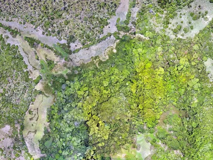
By analyzing the information and data obtained from LiDAR, the scientists involved in the study concluded that the settlement pattern of the Casarabe culture represents a tropical low-density urban approach that uses civic ceremonial architecture and water management infrastructure construction involving a scale, monumentality, workforce, and spatial extent of settlement dispersion comparable to that of Andean cultures.
▲ Image from: Nature
Although today we don't know exactly what happened on the Kasarabe cultural area in the first place to make the land barren, the subsequent exploration will still have to be done with the help of manpower as well.
But the changes that LiDAR has brought to archaeological work have been highlighted by the fact that, in addition to new discoveries in the Kasarabe cultural area, the ancient Mayan city of Tikal has used LiDAR for mapping, through which to discover finds that are difficult to see with the naked eye and can bring the past more fully into the present.