A new study led by the University of Cambridge has obtained for the first time a detailed "image" of an unusual rock area at the junction with the earth's core about 3000 kilometers below the surface This mysterious rock area is almost directly below the Hawaiian Islands. It is one of several ultra-low speed areas - the so-called ultra-low speed area is because seismic waves are extremely slow when passing through these areas.
The study, published in the journal Nature communications on May 19 local time, revealed in detail the complex internal changes in one region for the first time, and revealed the landscape and operation process in the deep interior of the earth.
"Of all the deep internal features of the earth, these are the most fascinating and complex," said Zhi Li, a doctoral student in the Department of Geosciences at the University of Cambridge. "We now have the first reliable evidence to show its internal structure - this is a real milestone in seismology in the depths of the earth."
The earth's interior is layered like an onion: the center is an iron nickel core, surrounded by a thick layer called the mantle, and above it is a thin shell - the crust in which we live. Although the mantle is solid rock, its temperature is enough to make it flow very slowly. These internal convection transfer heat to the surface, promote the movement of tectonic plates and provide power for volcanic eruptions.
Scientists use the seismic waves generated by earthquakes to "look" under the earth's surface - the echoes and shadows of these seismic waves reveal images of deep internal terrain similar to radar. But until recently, the "image" of the core mantle boundary structure, a key area for studying the heat flow inside our planet, has been granular, which is difficult to explain.
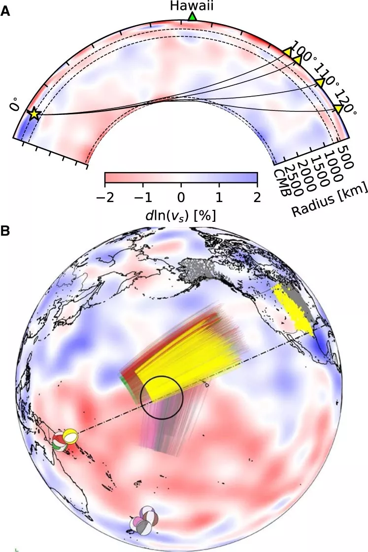
The researchers used the latest numerical modeling methods to reveal the kilometer scale structure of the core mantle boundary. According to the co-author of the research paper, Dr. kuangdai Leng, who developed these methods at Oxford University, "we really promote the limits of modern high-performance computing in elastodynamic simulation and take advantage of the symmetry of waves that have not been noticed or used before". Leng, who currently works at the Committee on scientific and technological facilities, said that this means that they can improve the resolution of the image by an order of magnitude compared with previous work.
The researchers observed that at the bottom of Hawaii's underground ultra-low velocity zone, the propagation speed of seismic waves decreased by 40%. This supports the existing suggestion that the area contains much more iron than the surrounding rocks - which means it is denser and slower. "This iron rich material may be a relic of ancient rocks in the early history of the earth, or even iron may have leaked out of the earth's core in an unknown way," said Dr Sanne cottaar, project leader of geoscience in Cambridge
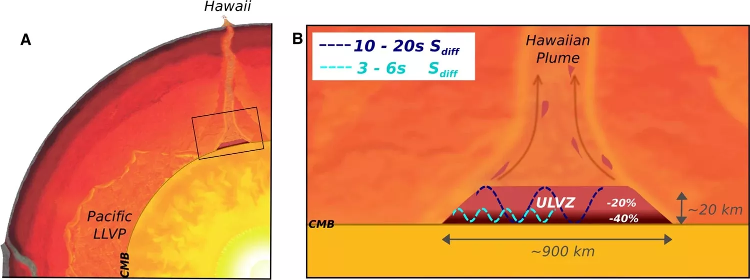
The study could also help scientists understand what lies beneath volcanic chains like the Hawaiian Islands and what happens. Scientists have begun to notice a correlation between the location of volcanoes described as hot spots, including Hawaii and Iceland, and the ultra-low velocity region at the bottom of the mantle. The origin of hot volcanoes has been controversial, but the most popular theory is that plum blossom structures bring hot mantle material from the core mantle boundary to the surface.
Now that they have images of the ultra-low velocity region below Hawaii, the team can also collect rare physical evidence from the roots of the plume that may provide food for Hawaii. Their observations of Hawaii's dense, iron rich rocks underground will support surface observations. "The basalt erupted from Hawaii has abnormal isotopic characteristics, which may point to the origin of the early earth or core leakage, which means that some of the dense material accumulated at the bottom must be dragged to the surface," cottaar said
More core mantle boundaries now need to be imaged to see if all surface hotspots have a bag of dense material at the bottom. Where and how to target the core mantle boundary depends on where the earthquake occurs and where seismometers are installed to record seismic waves.
The team's observations add to growing evidence that the depths of the earth's interior are as variable as its surface. "These low velocity regions are one of the most complex features we see at extreme depths - if we expand our search, we may see more and more complexity at the core mantle boundary, including structure and chemistry," Li said
Now, the team plans to apply their technology to improve the imaging resolution of other areas of the core mantle boundary and map new areas. Ultimately, they hope to map the geological landscape of the entire core mantle boundary and understand its relationship to the dynamics and evolutionary history of our planet.