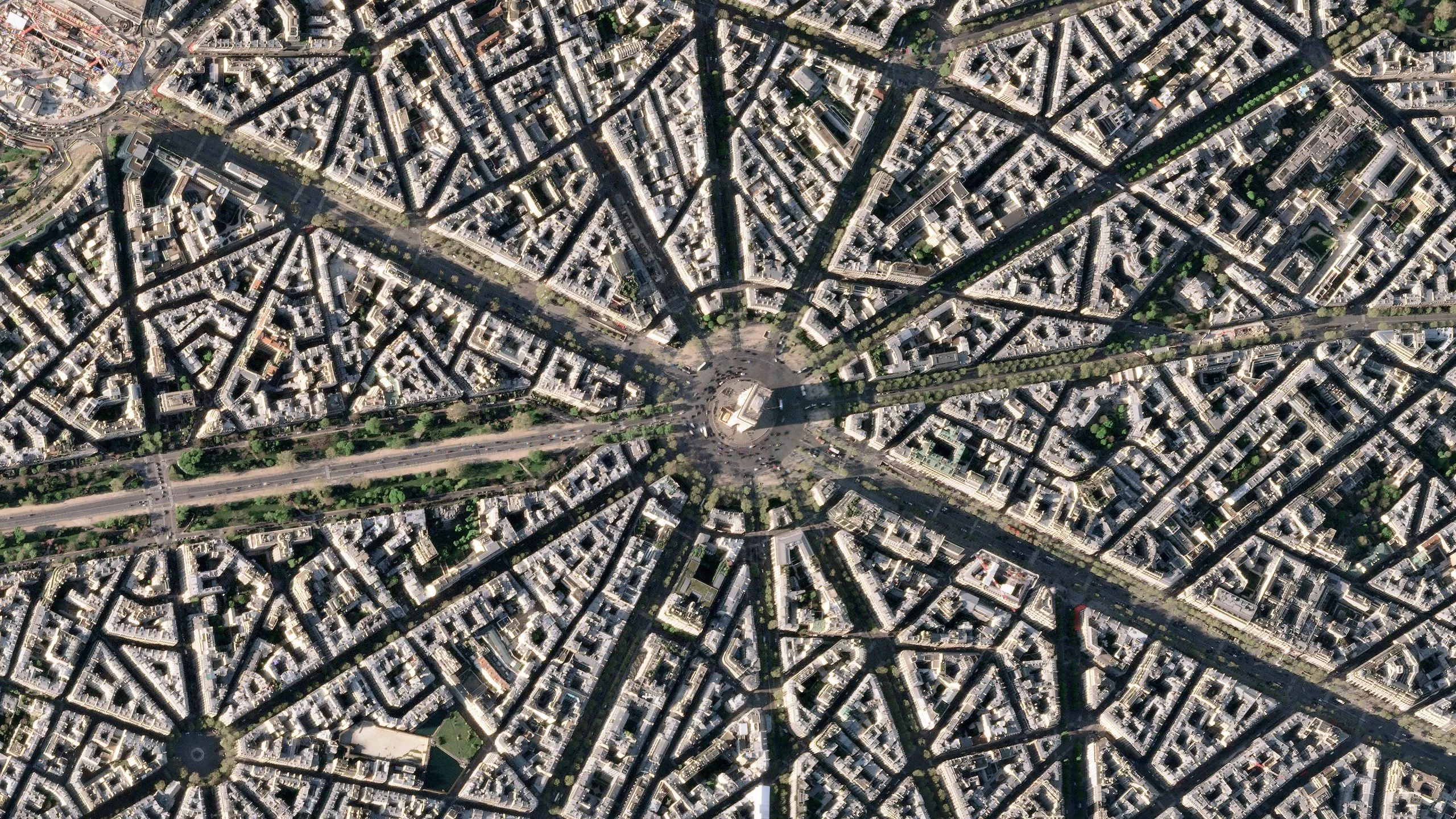
This spectacular high-resolution image of the Arc de Triomphe in Paris was taken by planet SkySat, a mapping satellite team that just joined the ESA third-party mission program in April 2022 Arc de Triomphe, the full name of Arc de Triomphe de l 'É Toile, is one of the most famous monuments in the world and a symbolic symbol of France.
The Arc de Triomphe was commissioned by Napoleon I in 1806 to celebrate the military achievements of the French army. The construction of the arch began the following year on Napoleon's birthday (August 15).
The arch stands in the center of Charles de Gaulle square and is the intersection of 12 roads. These roads form a star (or é Toile), which is why it is also known as the star triumphal arch. The arch is 50 meters (164 feet) high and 45 meters (148 feet) wide.
The names of all the French victors and generals are engraved on the inner and outer surfaces of the arch, while the tomb of the unknown soldier in World War I lies under the arch. The flame of the tomb is rekindled every night, symbolizing the lasting memory and respect for those who died in the name of France.
Located in Charles de Gaulle square, the Arc de Triomphe is the center of the capital and the west end of the Champs Elysees (visible at the bottom right of the picture). Often known as "the most beautiful avenue in the world", the Champs Elysees is famous for its dense distribution of theatres, cafes and luxury stores. It is the end of the tour de France and the annual military parade on Bastille Day.
This image was taken on April 9, 2022 and provided by planet SkySat - a fleet of 21 very high-resolution satellites that can collect images multiple times a day. The satellite image of SkySat has a spatial resolution of 50 cm, and its height is high enough to focus on the area of great interest. It can identify objects such as vehicles and transport containers.
SkySat's data, together with planetscope (both owned and operated by planet labs), serves many commercial and government applications. These data are now available through ESA's third-party mission program - enabling researchers, scientists and companies around the world to access planet's high-frequency, high-resolution satellite data for non-commercial purposes.
In this plan, planet, together with more than 50 other tasks, added nearly daily planetscope images, 50 cm SkySat images and rapideye archived data to the global network.
Peggy Fischer, ESA third-party mission manager, commented: "we are very pleased to welcome planetscope and SkySat to the ESA third-party mission portfolio and begin distributing planet data through the ESA earthnet program.
"The high-resolution and high-frequency images from these satellite constellations will provide valuable resources for the European R & D and application community and greatly facilitate research and business opportunities in a wide range of fields."
The picture also appears in the video program earth from space embedded on this page: