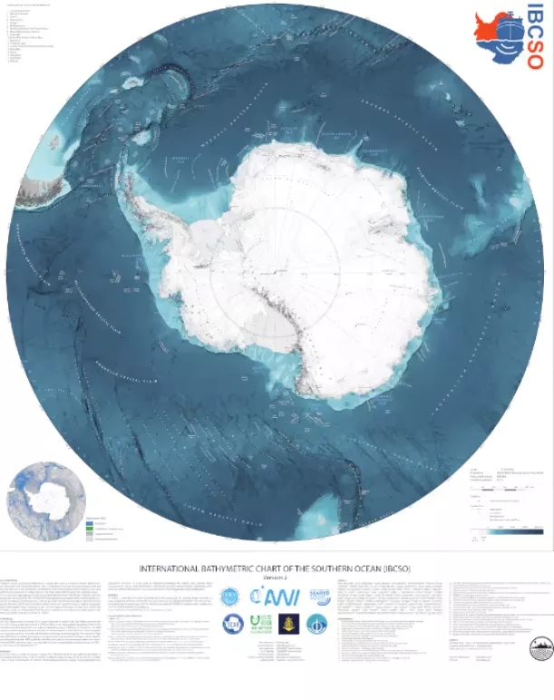
An international team of scientists and cartographers has released the most detailed undersea map of the Southern Ocean around Antarctica in history It covers 48million square kilometers (19million miles), including the deepest site ever found in the region.
Although a great deal of efforts have been made since the voyage of the challenger in 1873, the bottom of the world's oceans is still a mystery to a great extent. According to the data of the National Oceanic and Atmospheric Administration (NOAA), only 10% of the seafloor has been mapped with modern sonar methods. The ocean maps people see in different places cover up the fact that these maps are based on very incomplete low-resolution data.
This is not surprising, because three quarters of the earth's surface is water, with a depth of 10984 meters. To make matters worse, the seabed is highly dynamic and changes at an alarming rate, so organizations such as NOAA and the Royal Navy must constantly send survey ships to ensure that the navigation map is up-to-date.
This means that the kind of comprehensive land map we have, despite its many shortcomings, is not practical at all. Therefore, the bathymetric surveys carried out by vessels such as the British Antarctic Survey's "jamescalarross" must be supplemented by bathymetric surveys by commercial and research vessels, as they are operating.
The latest map, known as the international bathymetry of the Southern Ocean (ibsco), will not only help ships navigate safely, but also provide scientists with a valuable research tool to better understand the environment, weather and climate of the region. It extends the previous map by 10 degrees to the north, covering 2.4 times the previous area. Divided into 500 meter grid blocks, 23% of these map blocks have at least one modern sonar depth measurement.
Of particular interest is that the new map includes the factorian deep, which is the deepest known point in the Southern Ocean. It is located in the South Sandwich trench, about 100 kilometers east of the South Sandwich Islands, with a bottom of 7432 meters. It was discovered by the manned submersible DSV limiting factor in 2019 and was named "limiting factor" at the suggestion of Victor veccovo, the leader of the exploration team.
"This map has a huge impact on scientific research," said Rob Larter, a British Antarctic Survey geophysicist and co-author of the map. "It will help us understand how the shape of the seafloor affects the path of major ocean currents and the way seawater mixes, which affects how it transfers heat and then affects temperatures around the world. This is a very important factor in predicting climate change."
Ibsco can be found in the project website The study was published in pangea 》Up.