The only memory I have of Sweden before is of Pippi Longstocking, the freckled, domineering, but kind-hearted and chivalrous girl from the fairy tale books of my childhood. Now it's a nine-hour flight from Beijing to this fairy-tale country, and it's polar day in August at the Arctic Circle, so we'll complete the 110km hike in five days with almost no day or night.
The Arctic Circle's kiruna (Kiruna) is a haven for winter outdoor sports such as cross-country skiing, dog sledding, ice fishing and cross-country snowmobiling, and in summer, when the lakes and wilderness shed their thick white blankets, the climate is perfect for summer hiking, known as "Europe's last wilderness place". The hike starts in Nikkaluokta, a Sami village in southern Sweden, and passes through the famous mountainous region of Kungsleden to reach Abisko Park.
Kiruna is located on the eastern shore of Lake Rosa, 140 km north of the Arctic Circle, and is currently one of the largest iron ore mines in the world. The iron ore has been mined for over 70 years and has now been converted from open-pit to underground mining, which is probably why there are no visible signs of industrialization along the way. There are just a lot of houses painted in bright red, a metallic pigment that was used when the mine was first opened and has endured for ages.
Those who come on the trek park in Kiruna and then take a uniform bus to the start of the trek the following day. Spectacular RV and tent campsites are formed here. Some of the tents are attached directly to the side of the vehicle and are almost one room, big enough for a kitchen and bedroom; others are pitched directly on top of the vehicle and are self-contained with the roof, a style that is probably used for wolf-proofing in the wilderness and should be equally useful for lone wolves and perverts. We stayed in one of the few huts in the camp, which looked like a public toilet, but was small but well-equipped, with a kitchen, a bathroom and two separate single rooms, and although the beds were less than a meter wide, they were very comfortable for us, and we might have to sleep in the wind for the next few days. There was a long broom at the front door of the house, and the local custom is that the broom is put to one side to indicate that someone is in the house, and the broom is against the door to indicate that the owner is not at home. This shows that the local people are simple and open-minded, and that people live a relaxed and peaceful life.
Here you can receive the first two or three days of food, mainly frozen or dehydrated food packets, are high in calories, but this thin paste only meets the Western taste, the Chinese stomach can not stand to eat more, some team members brought instant noodles, do not underestimate this in the usual regarded as junk food fast food, in the next few days can become a sought-after goods.
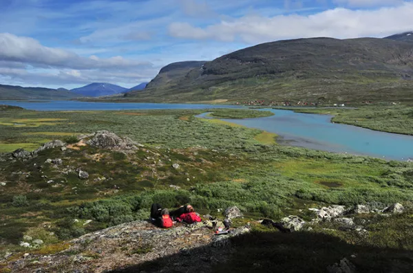
The Fjallraven classic started in 2005 with just over a hundred participants, but now there are 2,000 participants each year, with tens of thousands of people walking the route throughout the year. Two thousand people set off in different batches over three days, with a few hundred trekking the trail each day. While those at the front of the pack are competing for places, most people enjoy the hike and the fun without rushing. The greatest feeling of participating in the Fjallraven classic is that the outdoors is not exclusive to young people, all ages, genders and even animals can go on the trail together, you and I are all outdoors.
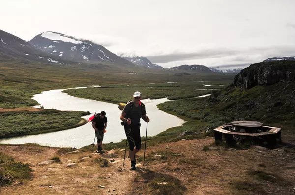
Although it is summer, there is still some snow on the surrounding mountains, giving a richer variation to the monotonous mountains. Sometimes a waterfall halfway up the mountain will split the snow and pour down, while the thick snow remaining on the cliffs hangs on, and the snow and waterfall exist together. The most common plant I saw on the roadside was a white fluffy ball-like plant, with thin, goatee-like leaves growing from its roots, often blooming in patches in the surrounding marshes, which made walking through it feel very dreamy. At first I thought it was a snowdrop from the Arctic Circle, but later I was looking through a booklet of local specimens in the checkpoint restaurant and found out that the name of the plant was "Eriophorum vaginatum".
The mountains are misty and foggy, which fits my mental picture of the Nordic landscape, brooding and regal. Understated, not gaudy.
Near the end of the first day's hike is Sweden's highest peak, Kebnekaise, which is just over 2,000 metres above sea level, but has a very varied climate, the summit resembling a giant volcanic crater, with clouds spewing out from the top like a giant white torch. Carl, the guide, points to the col on the right and says that in winter they often climb up and ski down. Imagine getting away with skiing and watching the aurora borealis here in the winter.
Kiruna's location meant extreme days in June and July, and in August, the sun was only hidden for a short time in the middle of the night, rearing its head after 3am. The camping headlamps we brought didn't come in handy once. The biggest nuisance of camping was the mosquitoes, which strangely enough did not bite the locals, and Carl, our guide, wore shorts and bare legs, and the mosquitoes did not make a fuss, but instead attacked us armed to the teeth.
Camp near the checkpoints at Salka and Alesjaure, and if the women are open-minded and the men are confident enough, try the authentic Finnish sauna, which is co-ed and can't be hidden during the extreme day. Next to the river, you can jump into the water afterwards and enjoy yourself.
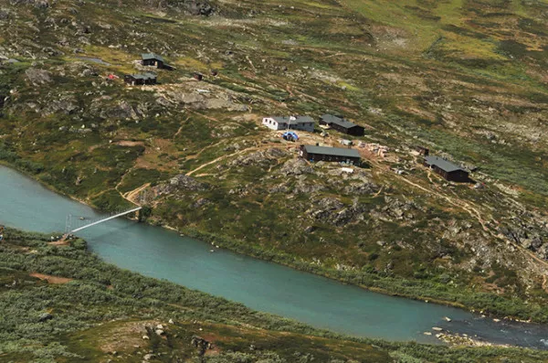
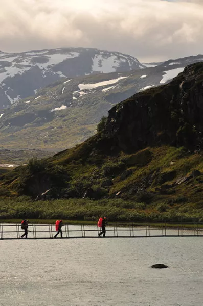
There are checkpoints (checkpoints) every 20 or 30 kilometers along the 110-kilometer trek, where food, lodging and even a kitchen are provided, and supplies are transported in by helicopter. At each checkpoint trekkers can find large blue tents with postmarks so that at the end of the trail they can receive a gold medal for completing the entire trek by showing the postmarks of all six checkpoints along the way.
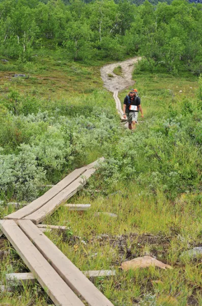
The entire route has little elevation gain and loss, and is basically a gentle mountain trail. There are wooden treks laid along the route in all the bad sections, and you can walk the entire route basically without getting your shoes wet, which is convenient for backpackers and protects the vegetation at the same time. It's no exaggeration to say that I didn't see a single plastic bottle, a single plastic wrapping bag, left on the trail during the 110km-long trek. The concept of "Carry in, carry out" is deeply rooted in every trekker's mind. At the starting point, everyone is given a green nylon bag to put their own garbage and encouraged to pick up trash along the way. At the end of the walk, there is a place to weigh the garbage bags, and the trekker with the heaviest bag will be rewarded with a Fjallraven classic backpack.
Penalties for littering are very strict here, with immediate disqualification from the event if caught, and such behaviour is against Swedish environmental law and can be reported to the Swedish police.
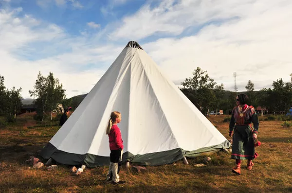
The Sami are the only minority in Sweden and they still make a living from reindeer husbandry. Near the checkpoint on the third day there was a Sami village which we went to visit. En route we had to walk through wet shrubs and swamps, which are also a haven for mosquitoes, and we were still attacked like crazy, with the locals living peacefully and unhindered. Most of the Sami live here for only one month a year, tagging reindeer, and only a few people live in the village during this season. The one Sami family that remains now has a wife who runs a tent shop near the checkpoint, offering drinks, barbecues, etc. to passing hikers, and a husband who runs the daily ferry. There are a few people at the entrance of the village who are repairing their houses and we ask one of them how many reindeer are in his family and the answer is 3,000. After tagging in the summer, the people scattered to the surrounding valleys.
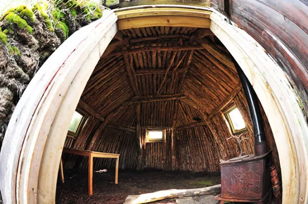
Although the Sami have been hunting reindeer since long ago, large-scale herding began only a few centuries before this. Previously, the Sami migrated with their reindeer, living in tents or straw huts and leading a nomadic life. This nomadic life has now effectively disappeared, with the herders living in permanent houses, and many Sami making their living from farming, forestry, freshwater fishing and mining, or being employed in towns and cities in government departments, industry and commerce. Several villagers pointed us to an old Sami house that is still intact, a conical mud house with a sturdy internal skeleton made of tree branches that has survived for many years. It is said that one of these structures remains in every village, though it is no longer used for housing, but only as a memorial.
It can often be felt in Europe that anything with the slightest trace of history is carefully preserved, proudly displayed, framed on walls or built into museums large or small for remembrance.
The scenery near the end of the section is very much like Kanas in Xinjiang, with slightly yellowing birch forests reflecting in the quiet lakes and large rivers rushing out of the gorge in an imposing manner. Each hiker who reached the end of the trail, Abisko, was rewarded with applause. People who had walked the entire distance gathered on both sides of the road, relaxing and enjoying coffee, wine and sunshine, giving the most sincere cheers to each of the windy arrivals. It was a most satisfying moment after five days of hiking.