This radar image taken from space by the Copernicus sentinel 1 mission shows us the only island city country: Singapore, officially known as the Republic of Singapore, which is one of the busiest ports in the world. Given its small geographical area and a population of about 5.6 million, it is the second most densely populated country in the world, second only to Monaco. (Monaco has no more people than Singapore, but its land area is smaller).
Singapore has four official languages: English, Malay, Putonghua and Tamil. According to the Singapore constitution, Malay is the official language, but English is the most commonly used universal language.
Singapore is located at the southern tip of the Malayan Peninsula, between Malaysia and Indonesia, 84 miles (135 kilometers) north of the equator. It consists of 270 square miles (710 square kilometers) of Singapore Island, and about 63 satellite islands and islets, which can be seen at the top center of the image.
Nearly two-thirds of Singapore's islands are less than 50 feet (15 meters) above sea level. TIMA mountain, the highest mountain, is only 538 feet (165 meters) above sea level. Changi Airport is one of the largest transportation hubs in Asia and the most highly praised airport in the world. It can be seen at the eastern end of the island.
The north of Singapore Island is separated from the Peninsular Malaysia by the Johor Strait, which is a narrow strait crossed by highway and train Causeway, while the south end faces the Singapore Strait, where the Riau Linga Islands (part of Indonesia) extend.
Singapore is the largest port in Southeast Asia and one of the busiest ports in the world. The port provides connections with more than 600 ports in 123 countries. Its growth and prosperity are attributed to its position at the southern tip of the Malay Peninsula. It dominates the Strait of Malacca, which connects the Indian Ocean and the South China Sea.
The image sent back by sentinel Copernicus 1 contains satellite data spliced from three independent radar scans to detect changes between acquisitions. The sea surface reflects the radar signal from the satellite, which makes the water look very dark in the image and forms a contrast with the metal objects. In this case, the ships and vessels look very bright in the dark water and become shining points.
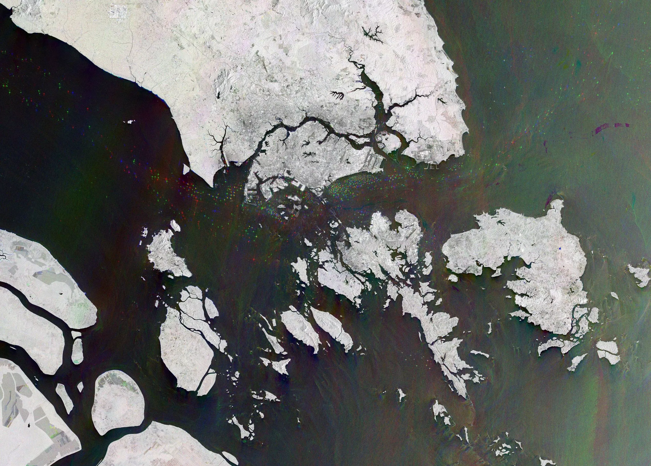
In this picture, ships on December 28, 2021 are shown in red, ships on January 9, 2022 are shown in green, and ships on January 21, 2022 are shown in blue. The various colors in the ocean are caused by the changing surface water flow and sediments in the River Delta, while major cities and towns are shown in white due to the strong reflection of radar signals.
The advantage of radar as a remote sensing tool is that it can image the earth's surface through rain and clouds, both day and night. This is particularly useful for monitoring areas prone to prolonged darkness, such as the Arctic, or for providing images for emergency response under extreme weather conditions.